
Description
Canadian Hydrographics Sailing Directions BC Coast PDF Files
For PAC203 follow the link below
https://waves-vagues.dfo-mpo.gc.ca/library-bibliotheque/chs-shc-PAC203-eng-202511-41307227.pdf
Canadian Hydrographic Service: Sailing Directions for the Pacific Coast
An Overview of Navigation Guidance and Marine Safety Resources
Introduction
The Canadian Hydrographic Service (CHS), a division of Fisheries and Oceans Canada, produces authoritative publications known as Sailing Directions for mariners navigating Canadian waters. These guides are essential for safe and efficient passage along the country’s extensive coastlines. This write-up focuses on the Sailing Directions for the Pacific Coast of Canada, offering an overview of their content, importance, and usage for both recreational and commercial vessels.
What are Sailing Directions?
Sailing Directions are comprehensive narrative guides that complement nautical charts. While charts provide the visual layout of coastlines, depths, and hazards, Sailing Directions offer detailed written descriptions of coastal features, anchorages, harbours, navigational hazards, regulations, and local knowledge. They are regularly updated to reflect changes in navigation aids, port facilities, and regulations.
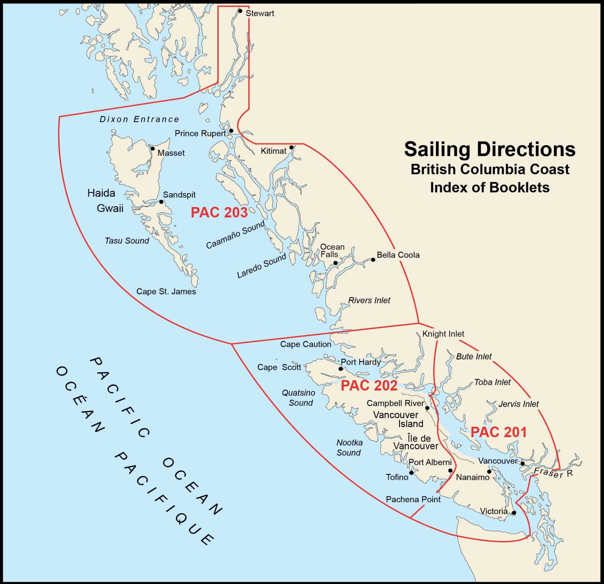
Coverage of the Pacific Coast
The Pacific Coast of Canada, primarily the coastline of British Columbia, is one of the most complex and scenic maritime regions in the world. The CHS Sailing Directions for this area are divided into several volumes, each covering distinct geographic regions such as:
- Juan de Fuca Strait and Strait of Georgia: Including approaches to Vancouver and Victoria, and the Gulf Islands.
- Vancouver Island: Detailing the outer coast, inlets, and harbours.
- North Coast and Queen Charlotte Sound: Including the Inside Passage, Hecate Strait, and approaches to Prince Rupert.
- Haida Gwaii: Covering the archipelago’s unique waters.
Each volume is organized into chapters that correspond to natural navigation sections, making information easy to locate while underway.
Key Content of Pacific Coast Sailing Directions
- Coastal Descriptions: Detailed narratives of the coastline, headlands, bays, islands, and river mouths.
- Navigation Hazards: Information on rocks, shoals, reefs, tidal streams, and seasonal weather considerations.
- Ports and Anchorages: Guidance on entering ports, harbours, and recommended anchorages, including depths and facilities.
- Regulatory Information: Details on traffic separation schemes, speed limits, restricted areas, and reporting requirements.
- Local Knowledge: Insights from local pilots and mariners, including tips on currents, wind effects, and unique challenges of the Pacific Coast.
Importance for Mariners
The Pacific Coast is characterized by strong tides, rapidly changing weather, intricate passages, and remote stretches. Accurate, up-to-date Sailing Directions are critical for:
- Safe Navigation: Helping mariners avoid hazards and understand coastal geography.
- Voyage Planning: Supporting route selection, timing, and contingency plans.
- Regulatory Compliance: Ensuring adherence to Canadian and international maritime rules.
- Environmental Protection: Highlighting sensitive ecological areas and best practices.
Accessing CHS Sailing Directions
Canadian Hydrographic Service Sailing Directions are available in digital formats. Mariners are encouraged to use the latest editions, as updates may include Notices to Mariners and corrections. Publications can be purchased through authorized chart dealers or accessed online via the CHS official website.
Conclusion
For any vessel operating along the Canadian Pacific Coast—from pleasure craft to commercial shipping—the CHS Sailing Directions are an indispensable resource. They bridge the gap between charted information and practical, on-the-water experience, promoting safe, efficient, and environmentally responsible navigation.