| Chart |
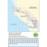
3495 Indian Arm, 3000 Juan de Fuca straight to Dixon Entrance, 3001 Vanc. Island Juan de Fuca Straight to Queen Charlotte Sound, 3002 Qn. Charlotte Sound to Dixon Entr., 3050 Kootenay Lake and River, 3052 Okanagan lake, 3053 Shuswap lake, 3055 Waneta to Hugh Keenleyside Dam, 3056 Hugh Keenleyside Dam to Burton, 3057 Burton to Arrowhead, 3058 Arrowhead to Revelstoke, 3061 Harrison Lake and Harrison River, 3062 Pitt River and Pitt Lake, 3080 Stuart Lake, 3311 Sunshine Coast/Vancouver Hbr.to desolation Sound, 3312 Jervis Inlet and Desolation Sound, 3313 Gulf Islands, 3410 Sooke Inlet, 3411 Sooke, 3412 Victoria Harbour, 3419 Esquimalt Harbour, 3424 Approaches to Oak Bay, 3440 Race Rocks to D'Arcy Island, 3441 Haro Strait, Boundry Pass and Sattelite Channel, 3442 North Pender Island to Thetis Island, 3443 Thetis Island to Nanaimo, 3447 Nanaimo Hbr. and Departure Bay, 3458 Approaches to Nanaimo Hbr., 3459 Approaches to Nanoose Hbr., 3461 Juan deFuca Strt.Eastern Portion, 3462 Juan de Fuca Strt. to Strt. of Georgia, 3463 Strt. of Georgia Southern Portion, 3473 Active Pass, Porlier Pass and Montague Hrbr., 3475 Plans-Stuart Channel, 3476 Approaches to Tsehum Hrbr., 3477 Plans-Gulf Islands, 3478 Plans-Saltspring Island, 3481 Approaches to Vancouver Hrbr., 3488 Fraser River, Crescent Isl. to Harrison Mills, 3489 Fraser River Patullo Bridge to Crescent Isl., 3490 Fraser River, Sand Heads to Douglas Isl., 3491 Fraser River, North Arm, 3492 Roberts Bank, 3493 Vancouver Hrbr.Western Portion, 3494 Vancouver Hrbr.Central Portion, 3512 Straight of Georgia. Central Portion, 3513 Strt. of Georgia, Northern Portion, 3514 Jervis Inlet, 3515 Knight Inlet, 3526 Howe Sound, 3527 Baynes Sound, 3534 Plans-Howe Sound, 3535 Plans-Malaspina Strait, 3536 Plans-Strait of Georgia, 3537 Okisollo Channel, 3538 Desolatiion Sound and Sutil Channel, 3539 Discovery Passage, 3540 Approaches to Campbell River, 3541 Approaches to Toba Inlet, 3542 Bute Inlet, 3543 Cordero Channel, 3544 Johnstone strt., race Passage and Current Passage, 3545 Johnstone Strt.Port Neville to Robson Bight, 3546 Broughton Strt., 3547 Queen Charlotte Strt.East Portion, 3548 Queen Charlotte Strt. Central Portion, 3549 Queen Charlotte Strt.Western Portion, 3550 Approaches to Seymour Inlet and Belize Inlet, 3552 Seymour Inlet to Belize Inlet, 3555 Plans Vicinity of Redonda Isl. and Loughb. Inlet, 3559 Malaspina Inlet, Okeover Inlet,Lanc.
|